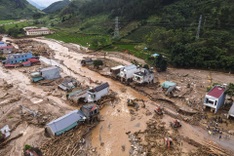
In Thuan Hoa Ward, roads have turned into rivers as locals use small boats to navigate their neighbourhoods. According to Hue City’s Civil Defence Command, days of heavy rainfall have forced upstream reservoirs on the Huong and Bo rivers to release up to 1,800 cubic metres per second, causing water levels to surge and flood low-lying areas.

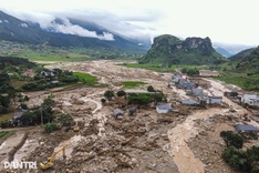
At Phu Oc station on the Bo River, water levels were forecast to reach 5.3 metres, close to the 2020 record, while the Huong River was expected to peak at 5.2 metres, about 1.7 metres above the third warning level. Other rivers, including the Truoi and O Lau, also rose between 2.8 and 4.3 metres.

Floodwaters overflowed the Da Dam Bridge on the Huong River, regarded by locals as a natural gauge for Hue’s flood severity, prompting authorities to block traffic and restrict access for safety.

By midday on October 27, major streets such as Hung Vuong, Ba Trieu, and Nguyen Hue were submerged, with residents using boats to move around, some charging VND 50,000 (approximately USD 2) per trip.

Rescue teams were deployed across the city as floodwaters surrounded apartment blocks in An Van Duong, while residents moved vehicles to higher ground and tried to keep water out of their homes.

In nearby mountainous areas, a landslide on Kim Quy Pass along National Highway 49, which connects Hue to A Luoi Commune, caused severe traffic disruption.

Local authorities have assisted residents in evacuating to safe areas, according to Hue police.