At 7a.m. on September 7, Yagi was about 150km off the northern coast of Vietnam, packing winds of between 150-166kph near its centre.
In the next three hours, Yagi will move west-northwest at a speed of about 15-20kph approaching the coastline of Quang Ninh and Hai Phong.
Although the storm has yet to make landfall, people in coastal localities from Quang Ninh to Thanh Hoa have already felt its power.

Co To Island District of Quang Ninh province is experiencing heavy rain and strong winds, with gusts reaching 118-133kph at times.
Strong winds have brought down many big trees, while fences, signs, and smaller trees have been knocked down, lying scattered across the streets.

Since September 7 morning, Yagi has started impacting the mainland. Strong winds are expected to strengthen and gradually extend southward through Quang Ninh province, and then to Thanh Hoa, Thai Binh, and Nam Dinh provinces.
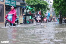
Rain has begun falling for the past hours and is anticipated to increase in intensity in the mainland provinces and cities.
Meteorologists warned that Yagi could dump more than 300mm or even 500mm of rain on some parts of the northern region that would cause severe flooding.
The National Center for Hydro-Meteorological Forecasting has recommended that residents of five localities - Quang Ninh, Hai Phong, Thai Binh, Nam Dinh, and Ninh Binh – stay indoors when the typhoon makes landfall.
It has also warned that the mountainous and midland areas of northern and north-central regions would face risks of flooding, flash floods, landslides, and soil erosion, especially for temporary shelters, buildings near mining sites, and low-lying areas.