Heavy rains on October 6-7, combined with surging upstream floodwaters, have pushed Thuong and Cau rivers in Bac Ninh above their previous record levels.

The National Centre for Hydro-Meteorological Forecasting reported that floodwaters on Thuong and Cau rivers peaked at 18.37 metres at Cau Son Station and 7.6 metres at Phu Lang Thuong Station early this morning, October 9, with the latter surpassing the 1986 historic flood by 0.08 metres.

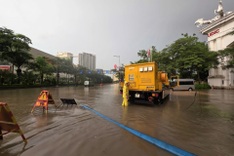
Rising floodwaters have severely inundated a series of riverside communes along the Thuong River in Bac Ninh, including Tien Luc and Bo Ha.

Around 8 am today, many areas in Tien Luc Commune near Bo Ha Bridge were submerged under 4-5 metres of floodwater, leaving numerous villages completely isolated.

The road linking the commune to the surrounding areas has turned into a muddy stretch of water, cutting off transportation and daily activities for local residents.

Floodwaters kept rising this morning, flooding villages like Ben Pha, Bo No, and Xom Cham in Tien Luc Commune.

Road 392 was submerged overnight, bringing traffic to a standstill.

Within just one hour, from 8 to 9 am today, floodwaters rose by 40-50 centimetres.

“In nearly 60 years, I’ve never witnessed such severe flooding. Even during the historic flood of 1986, the water only reached about one to two metres inside residential areas, nothing like what we’re seeing now,” said a local resident.

Authorities quickly set up temporary evacuation sites at schools, cultural halls, and village offices to help residents move their belongings and valuables to safety.

Forecasts indicate that within the next 24 hours, water levels on the Thuong River will keep falling, about 1.4 metres above alarm level 3 at Cau Son Station and 0.5 metres at Phu Lang Thuong, with flooding in Bac Ninh’s lower areas likely to persist for another two to three days.