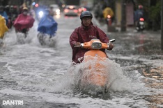
People living and working in Ho Chi Minh City will be able to avoid flooded areas by receiving necessary information on their smartphone, both iOS and Android, from the UDI Maps app created by the Ho Chi Minh City
People living and working in Ho Chi Minh City will be able to avoid flooded areas by receiving necessary information on their smartphone, both iOS and Android, from the UDI Maps app created by the Ho Chi Minh City Urban Drainage Company Limited after a trial run on Android devices ended successfully.
After downloading UDI Maps, users can determine rain and flood forecasts on roads, as well as tides. They can then select the best route to their destination.
According to the software development unit, information on rain, flooding and tides come from automated measurement stations and staff in districts.
Traffic jams and flooding are two issues Ho Chi Minh City’s residents must frequently face. With the growing number of smartphone users, city authorities decided to software to spread available information.
The Saigon River Tunnel Management Center previously introduced a traffic jam prevention app, to help people identify congested areas, with information also available on parking lots and public toilets.
Three Vietnamese-American sailors serving aboard USS George Washington said they were delighted to return to Vietnam during the US aircraft carrier's...
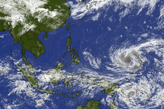
Northern Vietnam is forecast to see increasing thunderstorms from August 2, while Super Typhoon Dolphin is expected to maintain its peak intensity as...
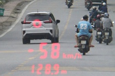
Police in Lao Cai Province have fined a Chinese driver for speeding and driving without a valid licence, while the vehicle owner also faces penalties...
Authorities in Lam Dong Province have ordered inspections of street food vendors after two mass food poisoning outbreaks linked to banh mi within the...