Dong Nai Provincial People’s Committee had previously issued a directive in response to public concerns that the design of the Bien Hoa-Vung Tau Expressway was inconsistent with local hydrological conditions and could pose a serious flooding risk. The committee assigned the board to coordinate with concerned agencies to conduct surveys and develop comprehensive solutions.

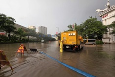
Flooding in Phuoc Tan Ward as Buong River rises (Photo by Hoang Binh)
The project will expand nearly 7 kilometres of the Buong River in Phuoc Tan Ward, including 4.3 kilometres with sloped banks and 2.6 kilometres with vertical embankments, requiring about 292,000 square metres of land clearance. It also calls for upgrading Ba Buom Canal, which is 3 kilometres long, 10 metres wide, and 4.5 metres deep.
Rapid urbanisation and low terrain along the Buong River have worsened flooding in recent years, especially from Giang Dien Commune to the Dong Nai River. In Phuoc Tan Ward, overflows often inundate areas 1.3-1.7 metres deep for up to 48 hours, severely disrupting local life.
Buong River, also known as Nhan River upstream, stretches nearly 83 kilometres from Long Khanh Ward, where it joins the Ben Go River, and flows into the Dong Nai River.
The river drains a 40,000-hectare basin spanning Long Khanh, Trang Bom, Phuoc Tan, Tam Phuoc, and Long Hung, while also supplying irrigation water and offering tourism potential in its upper reaches.