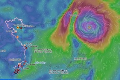
The National Centre for Hydro-Meteorological Forecasting said the storm's centre was about 400km south-east of Taiwan, China, on the afternoon of October 22. Maximum sustained winds near its centre reached level 16, with gusts above level 17, one level lower than on October 21.
Champi is forecast to move north-west at 15-20km/h over the next 24 hours.

Super Typhoon Champi is not forecast to enter the East Sea (Photo: Vietnam Disaster Monitoring System).
By the morning of October 23, as it approaches waters east of Taiwan, China, the storm is expected to weaken to levels 14-15, no longer meeting the classification of a super typhoon.
Around October 25, Champi is forecast to turn north before heading north-east towards Japan, continuing to weaken along the way.
By the time it affects Japan, the storm is expected to have weakened to level 8, with gusts reaching level 10.
Although Champi is not expected to enter the East Sea, its exceptional intensity and broad circulation could still generate strong winds and high waves in some Vietnamese waters over the next one to two days.
In the eastern part of the northern East Sea, winds could reach levels 6-7, with gusts at levels 8-9 and waves of two to four metres.
Conditions could be more severe in the north-eastern part of the northern East Sea, where winds may reach levels 8-9, with gusts at levels 10-11 and waves of four to six metres, creating very rough seas.
The National Centre for Hydro-Meteorological Forecasting said it was continuing to closely monitor the storm's development.