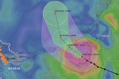
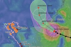
According to the National Centre for Hydro-Meteorological Forecasting, at 7am on August 18, the storm’s centre was at 18.8 degrees north latitude and 108.4 degrees east longitude, about 135 kilometres southeast of Bach Long Vi Island.
By 7am on August 19, the system was active over Quang Ninh and Lang Son with winds of level 6, up to 49 km/h, and gusts of level 8. By 7pm the same day, it weakened into a low-pressure zone over the Vietnam-China border, and by 1am on August 20, it had further weakened over southern Guangxi, China.
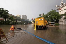
The system caused showers, thunderstorms and rough seas in waters from Quang Tri to Hue and across the Gulf of Tonkin, including Bach Long Vi and Co To islands.
Its circulation is forecast to bring widespread heavy rain of 50 to 300 millimetres to the northeast and Thanh Hoa Province through August 20.