According to the National Centre for Hydro-Meteorological Forecasting, at 4 pm on August 21, the storm was centred over the northern Gulf of Tonkin, about 80 kilometres east-north-east of Bach Long Vi special zone in Haiphong City.
Maximum winds near the storm's centre were at force 8, or 62-74 kilometres per hour, with gusts up to force 10. The storm was moving slowly northwards at about 3 kilometres per hour.
Under the storm's influence, Bach Long Vi special zone recorded force 8 winds with gusts of force 9, while Co To special zone in Quang Ninh Province saw force 6 winds with gusts of force 9.
By 4 pm on August 22, the storm is forecast to continue moving northwards at about 3 kilometres per hour over the northern Gulf of Tonkin, around 200 kilometres east of Haiphong City and 110 kilometres north-east of Bach Long Vi.
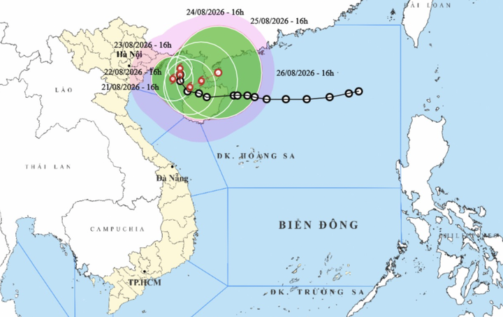
Projected path of the storm (Photo: NCHMF).
The storm is expected to maintain force 8 intensity with gusts up to force 10 at that point. Notably, it may then change direction.
By the afternoon of August 23, the storm is forecast to move southwards at about 3 kilometres per hour, around 140 kilometres east-south-east of Haiphong City and 50 kilometres north-east of Bach Long Vi.
By the afternoon of August 24, it is expected to turn south-eastwards and move at about 3 kilometres per hour into waters east of the Gulf of Tonkin, about 120 kilometres east of Bach Long Vi. Its intensity is forecast to remain at force 8, with gusts up to force 10 during this period.
Over the following 72 to 120 hours, the storm is forecast to turn north-eastwards, travel at 3-5 kilometres per hour and gradually weaken into a tropical depression.