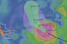
According to the National Centre for Hydro-Meteorological Forecasting, at 7 am today, October 2, the centre of Typhoon Matmo was located over the eastern waters of the Philippines, with maximum sustained winds of 62-74 km/h. Over the next 24 hours, it is expected to move west-northwest at a speed of 15-20 km/h.
By the morning of October 3, Storm Matmo was located off the eastern coast of Luzon in the Philippines, with violent winds. It may enter the East Sea on the evening of the same day.
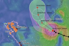
Under the impact of the storm, from the afternoon of October 3, strong winds of level 6-7 will develop over the northeastern East Sea, later strengthening to level 8. Areas near the storm’s centre may see winds of level 9-10, gusting to 12, with waves 4-6 metres high. The sea will be extremely rough.
The national meteorological agency warned that between October 4-5, the northern East Sea may be affected by winds of level 11-12, with gusts reaching up to 15. Vessels operating in these hazardous areas may encounter thunderstorms, waterspouts, strong winds, and high waves.