Serious erosion on the banks of the Red River has started to pose a threat to hundreds of households in Hanoi's Hoan Kiem and Hai Ba Trung districts.

The riverbank recedes 2 metres a year
The local Department of Agriculture Rural Development (DARD) has sent report about the erosion over the past years along the dyke in Chuong Duong Ward in Hoan Kiem District and Thanh Luong Ward in Hai Ba Trung District.
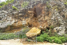
The section of river that runs through the two wards is 2,230 metres long and more than nine metres deep in some places. Erosion is not a new problem and some households that are located within 800 metres of the river were reinforced in 1984.
Each year, the banks are losing about 2 metres to erosion, receding 40 metres since 1995. The problem can be clearly seen near the headquarters of waterway traffic police, where 3 metre wide cracks have appeared nearby, tilting the buildings towards the river.
DARD has concluded that the erosion is largely due to human activity, such as dumping of materials and building too near the river. They also said that traffic along the river favours one side of the river, which contributes to further erosion.
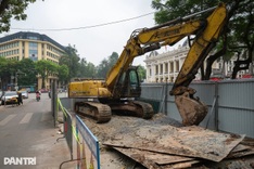
DARD has directed the management agencies to find ways to secure the river bank and the structures nearby.
In addition DARD is planning a VND115 billion (USD5.5 million) project to shore up the banks in Chuong Duong and Thanh Luong wards. The authorities of Hoan Kiem and Hai Ba Trung districts will be responsible for clearing the ground for the project.