Heavy rain causes serious flooding in Gia Lai Province on June 11.
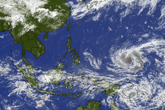
At 10 am on June 11, the National Centre for Hydro-Meteorological Forecasting reported that the eye of Typhoon Wutip was located at approximately 16.3 degrees North latitude and 113.4 degrees East longitude, in the eastern waters of the Hoang Sa (Paracel) archipelago.
The storm is moving west-northwest at a speed of around 10 kilometres per hour.
By 10 am on June 12, the typhoon is expected to continue on its west-northwest trajectory and intensify, with wind speeds reaching level 9 (75–88 km/h) and gusts at level 11. Affected areas include the Hoang Sa archipelago and offshore waters from Quang Tri to Quang Ngai provinces.
After that, the storm is forecast to change direction toward the north-northeast and gradually weaken.
Due to its influence, offshore areas from Quang Tri to Quang Ngai will experience strong winds and high waves of 2 to 4 metres beginning the night of June 11.
Central Vietnam is expected to receive heavy to extremely heavy rainfall, with average precipitation ranging from 100 to 300 millimetres and isolated areas exceeding 450 millimetres. The northern Central Highlands region is forecast to receive moderate to heavy rain and thunderstorms, with localised downpours reaching 70 to 150 millimetres and some areas exceeding 200 millimetres.
In Gia Lai Province, heavy rainfall from the night of June 10 through the morning of June 11 caused water levels to rise significantly, inundating roads and isolating hundreds of households in Ia Pa District.


