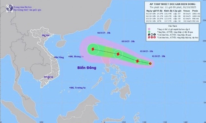
Tropical depression develops over waters east of Luzon, is likely to intensify within two days (Photo: NCHMF)
According to the National Centre for Hydro-Meteorological Forecasting (NCHMF), as of 10 am on October 1, the centre of the tropical depression was located over waters east of Luzon. Sustained winds near the center reached levels 6-7 (39-61 km/h or 24-38 mph), with gusts up to level 9 (75 km/h/47 mph). It was moving west-northwest at a speed of about 15 km/h
Forecasts indicate that by 10 am on October 2, the tropical depression will continue moving west-northwest at around 15 km/h and may intensify into a storm over waters east of Luzon, with winds reaching level 8 and gusts up to level 10 (90 km/h /56 mph).
By 10 am on October 3, the system is expected to move in the same direction at 20-25 km/h, with potential further strengthening into a storm.
Over the following 48-72 hours, the storm will likely continue west-northwestward at 25-30 km/h, entering the East Sea (known internationally as the South China Sea), and may intensify further.
Due to the influence of the tropical depression, from October 3, waters east of the northern East Sea will experience increasing winds of levels 6-7; near the storm’s center, winds could reach level 8 with gusts up to level 10 (approximately 90 km/h/ 56 mph). Wave heights are forecast to be 2.5-4.5 meters, creating rough sea conditions.
Between October 4 and 6, the northern East Sea (including Paracel Islands) is likely to face gale-force winds of levels 10-11 with gusts up to level 14 (135 km/h / 84 mph). Vessels operating in these hazardous areas may encounter thunderstorms, squalls, strong winds, and high waves.


