According to Vietnam's National Centre for Hydro-Meteorological Forecasting, at 4 pm on July 5, the centre of Super Typhoon Ba Vi was located about 2,500 km east of central Philippines. The storm had sustained winds of force 17, with gusts above force 17, making it the third super typhoon to form over the northwestern Pacific this year.
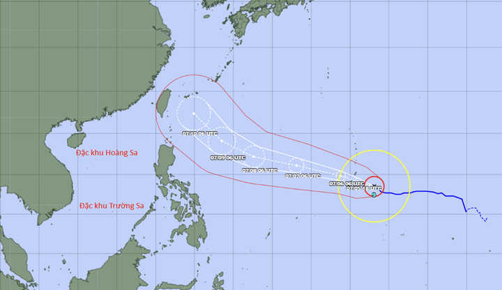
Forecast track of Super Typhoon Bavi by the Japanese meteorological agency (Photo: NCHMF).
Over the next 24 hours, the storm is forecast to move west, northwest at around 20 km/h. Between July 6 and July 9, Ba Vi is expected to maintain super typhoon intensity while continuing on a west, northwest track. From around July 10, it is forecast to turn northwest toward Taiwan (China).
The weather agency said the probability of Ba Vi entering the East Sea remains low, at below 10 per cent. However, due to its extreme intensity, the storm's outer circulation could affect the northeastern waters of the northern East Sea between July 9 and July 11.
In addition, the typhoon's circulation is expected to strengthen the southwest monsoon over the East Sea from July 9. Between July 9 and July 11, winds across the northern, central and southern East Sea, including the waters around the Hoang Sa and Truong Sa archipelagos, could reach force 6 to 7, with waves of 3 to 5 metres, resulting in very rough seas.
The National Centre for Hydro-Meteorological Forecasting said it will continue closely monitoring Ba Vi and issue updated forecasts as the storm develops.