Storm Matmo has weakened into a tropical depression and is forecast to bring heavy rain and thunderstorms to northern mountainous and midland areas through October 7, with rainfall of 100-200mm, and over 300mm in some places.
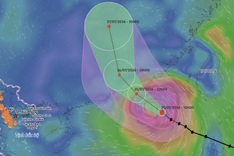
The National Centre for Hydro-Meteorological Forecasting said that on the morning of October 6, after making landfall in Guangxi Province, China, Storm Matmo, the eleventh to have formed over the East Sea this year, weakened into a tropical depression.
Under the tropical depression’s influence, the northern Gulf of Tonkin, including Bach Long Vi Island, is seeing winds of level 6, gusting to level 8, with 2-3m waves and rough seas this morning.
Quang Ninh and Lang Son provinces experienced winds of level 5, with gusts of 7-8 metres per second this morning.
From this morning until late October 7, northern mountainous and midland areas will experience heavy rain and thunderstorms, with rainfall of 100-200mm, locally exceeding 300mm. The northern delta and Thanh Hoa will experience moderate to heavy rain, ranging from 50-150mm, with some areas recording over 200mm.
The meteorological agency warned of thunderstorms, whirlwinds and strong gusts in Hanoi, where moderate to heavy rain of 50-100mm, locally over 150mm, is expected through October 7.
In recent hours, Lai Chau, Son La, Phu Tho, Lao Cai, Lang Son and Quang Ninh have seen moderate to heavy rain, with some areas nearly or fully saturated. Rainfall of 20-50mm, locally over 90mm, is expected to continue in the coming hours.
Possible flash floods on small rivers and streams, as well as landslides on slopes, have been warned for several communes and wards in Lai Chau, Son La, Phu Tho, Lao Cai, Lang Son, and Quang Ninh in the coming hours.
Storm Matmo formed over the eastern waters of the Philippines on October 2 and entered the East Sea a day later as the eleventh storm of 2025.
It moved into the northeastern waters of Hainan Island on May 5, intensified to level 12-13, then swept across Leizhou Island into the Gulf of Tonkin before making landfall in Guangxi Province, China, early on October 6.