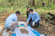
The survey was conducted by the Quang Tri Museum in coordination with the Nam Quang Tri Special Use Forest Management Board at a site in Huong Phung Commune.

The structure stretches 150 metres in length, about 0.6 metres wide and rises between one and five metres in height, featuring a notably flat and near vertical surface.
Investigators also discovered fragments of wartime ordnance in the surrounding area. Initial assessments suggest the formation may have resulted from a combination of bombing impacts during wartime and natural geological processes.
According to officials, the area consists mainly of limestone and may contain caves beneath the surface. Existing fractures, together with the force of explosions, could have triggered a cave collapse, creating the current rock face.
Following the survey, local authorities plan to develop further research measures and consider ways to utilise the site’s unique geological and potential historical features.