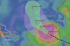
According to the National Centre for Hydro-Meteorological Forecasting, the eye of Storm Comay was located over the northern part of the East Sea early on July 24. Maximum sustained winds near the centre reached levels 8-9 (62-88 km/h), with gusts up to level 11.
The storm is moving southeastward at approximately 15 km/h.
By around 4 pm on July 25, the storm is expected to shift east-southeast, intensifying to level 9-10 winds with gusts reaching level 12, over the eastern sector of the northern East Sea.
The storm is bringing winds of level 7-8 to the eastern waters of the northern East Sea, increasing to level 9-10 near the centre, with gusts up to level 12. Waves may reach 4-6 metres, and the sea will be very rough.
Thunderstorms, squalls, strong winds, and high waves may hit vessels operating in these hazardous areas.