According to the National Centre for Hydro-Meteorological Forecasting, on the evening of August 21, the storm was active over the northern Gulf of Tonkin, about 90km north-north-east of Bach Long Vi special zone in Haiphong City.
The strongest winds near the storm's centre were at force 8, or 62-74kph, with gusts up to force 10. The storm was moving very slowly northwards at about 3kph.
Under the storm's influence, Bach Long Vi special zone recorded force 8 winds with force 9 gusts, while Co To special zone in Quang Ninh Province saw force 6 winds with force 9 gusts.
The meteorological agency forecast that by the evening of August 22, the storm would continue moving slowly northwards at about 3kph over the northern Gulf of Tonkin, around 120km east of Quang Ninh Province and 110km north-north-east of Bach Long Vi.
The storm's intensity during this period is forecast to remain at force 8, with gusts up to force 10.
By the evening of August 23, the storm may turn southwards but is still expected to move at only about 3kph. Its centre would then be over the northern Gulf of Tonkin, about 170km east-south-east of Haiphong City, maintaining force 8 winds and force 10 gusts.
A day later, the storm is forecast to shift again to the east-south-east, moving at a similar speed over waters east of the Gulf of Tonkin, about 120km east of Bach Long Vi and 270km east-south-east of Haiphong City.
From 72 to 120 hours later, the storm may turn north-east, accelerate to 3-5kph and gradually weaken into a tropical depression.
As the storm is expected to linger over the Gulf of Tonkin, forecasters warned that the area, including Bach Long Vi, Van Don, Co To, Cat Hai special zones and Hon Dau island, could see force 6-7 winds, rising to force 8 near the storm's centre, with gusts up to force 10. Waves are forecast at 2-4 metres, with very rough seas.
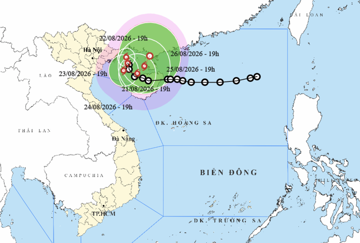
Projected path of the storm (Photo: NCHMF).
Vessels operating in hazardous waters risk being affected by thunderstorms, whirlwinds, strong winds and high waves.
Alongside the development of the storm, heavy rain is forecast to continue covering many parts of northern Vietnam in the coming days.
The meteorological agency said that from now until August 23, the north-eastern region, southern Phu Tho Province and Thanh Hoa Province would see moderate to heavy rain and thunderstorms, with rainfall generally at 70-150mm and isolated areas receiving more than 300mm.
Quang Ninh Province is forecast to be the centre of the downpour, with rainfall of 200-300mm and some places exceeding 500mm.
Lang Son Province, Bac Ninh Province and Haiphong City are expected to see heavy to very heavy rain, with totals of 150-250mm and isolated areas above 400mm.
Forecasters issued a particular warning over the risk of intense rainfall exceeding 120mm within just three hours.