
According to Hue's Irrigation and Climate Change Sub-Department, river levels were rising slowly on the morning of November 10, with most monitoring stations recording levels above alert level one.
At Kim Long Station on the Huong River, water reached 1.37 metres, exceeding alert level one by 0.37 metres.
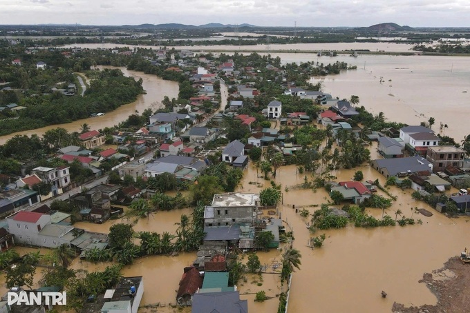
The Bo River at Phu Oc Station stood at 1.54 metres, 0.04 metres above alert level one, while the Ta Trach River at Thuong Nhat Station reached 60.06 metres, 1.06 metres above the same alert threshold.
Authorities warned that river levels could reach or exceed alert level two between November 10 and 12, posing a high risk of flooding in low-lying riverside and urban areas, along with flash floods and landslides on steep slopes.
Heavy rain has already caused localised flooding along the Ho Chi Minh Highway through Hop Thanh Village in A Luoi 2 Commune, with water reaching depths of 0.3-0.4 metres.
In Khe Tre Commune, roads through the centre were submerged under 0.2-0.3 metres of water.
Floodwaters at both locations had receded by the morning of November 10.
In Thai Duong Ha residential area of Thuan An Ward, strong winds, high waves and elevated tides flooded major roads to depths of more than 0.2-0.3 metres, disrupting traffic.
In nearby An Hai, waves and high tides eroded approximately 100 metres of coastline, with erosion extending 20 metres inland.
Hue's Department of Agriculture and Environment ordered a gradual increase in water discharge from Ta Trach Reservoir, through its spillway and hydropower turbines, to between 300 and 800 cubic metres per second from 2pm on November 10.
The city's Civil Defence Steering Committee also ordered Huong Dien Hydropower Reservoir to gradually increase discharge to 1,000-1,500 cubic metres per second from 7.30am.
Binh Dien Hydropower Reservoir began gradually increasing discharge to 200-800 cubic metres per second from 10am the same day.
Authorities instructed operators to avoid sudden increases in discharge rates.
From the evening of November 8 to the morning of November 10, mountainous areas of Hue recorded widespread rainfall of 300-500 millimetres.
Some locations received substantially more, including Bach Ma Peak with 760 millimetres, Khe Tre with 608 millimetres and A Luoi with 597 millimetres.
Further moderate to heavy rain, locally very heavy, is forecast from November 10 to 12, with rainfall generally reaching 170-350 millimetres and exceeding 500 millimetres in some areas.
Total rainfall for the entire spell is expected to reach 200-400 millimetres across Hue, with some locations receiving more than 600 millimetres.
Offshore, northerly to northeasterly winds are forecast at force six to seven, gusting to force eight or nine, with rough seas and waves reaching 2.5-4 metres.