
Authorities have stepped up monitoring and warnings, while evacuating residents and property from high-risk areas and seeking longer-term measures to curb further damage.
Severe erosion has occurred along sections of the Hau River in My Hoa Hung Commune, where riverbank land has continued to collapse, threatening nearby homes and roads.
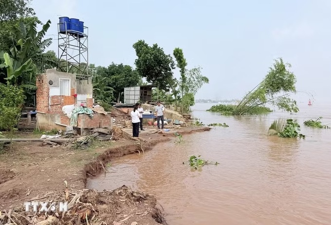
On September 9, a roughly 50-metre stretch of riverbank collapsed by about five metres in My Khanh 1 Hamlet. Another 50-metre section nearby had collapsed by around seven metres on August 25.
The two incidents forced six households to dismantle their homes and move people and property to safety.
No casualties have been reported, but dozens of households have been affected. Six households with 25 people were forced to completely dismantle their homes, with initial property losses estimated at around VND 500 million (USD 19,000), according to local authorities.
With no resettlement area currently available, affected families have been asked to stay temporarily with relatives or other local residents while awaiting permanent accommodation.
My Hoa Hung has two areas facing severe erosion risks, while a roughly two-kilometre stretch from Ut Na sluice to My Khanh 1 Hamlet is considered at high risk during the rainy and flood season.
Local authorities plan to seek provincial approval to put the My Long 1 residential area into use for long-term resettlement and propose central government support for a two-kilometre embankment along the Hau River.
From the start of 2026 to September 14, An Giang recorded 38 river, canal and stream bank erosion incidents across 23 communes, covering a combined 1,767 metres, according to the provincial Irrigation Sub-department.
The incidents, concentrated mainly along the Tien and Hau rivers, affected 21 houses, including five that collapsed completely and three whose kitchens fell into the river. Rural roads were also damaged and one iron-and-wood bridge was destroyed.
Total losses were estimated at more than VND 19 billion (USD 722,000).
Authorities said many of the erosion sites had previously been identified as high-risk areas. In My Hoa Hung, strong currents running close to the riverbank, combined with the weight of homes and roads above, have increased the risk of erosion and subsidence.
Monitoring has identified 56 river, canal and stream sections at risk of erosion across An Giang, with a combined length of more than 181 kilometres. Four are classified as extremely dangerous, three as dangerous to extremely dangerous and 49 as dangerous.
High-risk areas are concentrated along major waterways including the Tien, Hau and Vam Nao rivers, Xang Tan An Canal and Ong Chuong Creek, with both the extent and severity of erosion showing signs of increasing.
An Giang has built nearly 88 kilometres of embankments along rivers and canals, but limited funding and a shortage of resettlement land have hampered efforts to address erosion.
The province is seeking central government support for three urgent embankment projects covering eight high-risk areas.
The provincial Department of Agriculture and Environment has also proposed 20 anti-erosion embankment projects totalling more than 27.3 kilometres to protect residential areas, roads, urban centres, border areas and river islands.